AI-Based Tree Mapping System to Support Forest Management in Cyprus
Deep Learning Technology Used to Accurately Track Tree Coverage and Biomass

A new study by the Cyprus Institute introduces an innovative tree mapping system, utilizing deep learning models applied to high-resolution aerial photography.
According to an announcement by the Cyprus Institute, this research addresses the need for a reliable tree inventory in Cyprus, which is essential for effective forest management.
Recognizing that trees play a crucial role in mitigating the long-term effects of climate change and reducing greenhouse gas emissions, the study’s findings significantly improve monitoring and management of forest and urban ecosystems in Cyprus. This research also strengthens efforts to tackle the growing challenges posed by the climate crisis.
The study was conducted by researchers from the Center of Excellence for Climate and Atmospheric Research (CARE-C) at the Cyprus Institute, in collaboration with the Laboratory of Climate and Environmental Sciences (LSCE) in France and the University of Copenhagen in Denmark.
As part of the study, the first-ever comprehensive inventory and mapping of trees in both forested and urban areas of Cyprus was carried out using a cutting-edge artificial intelligence model. This model was specifically adapted and trained on Cyprus-specific data by the research team.
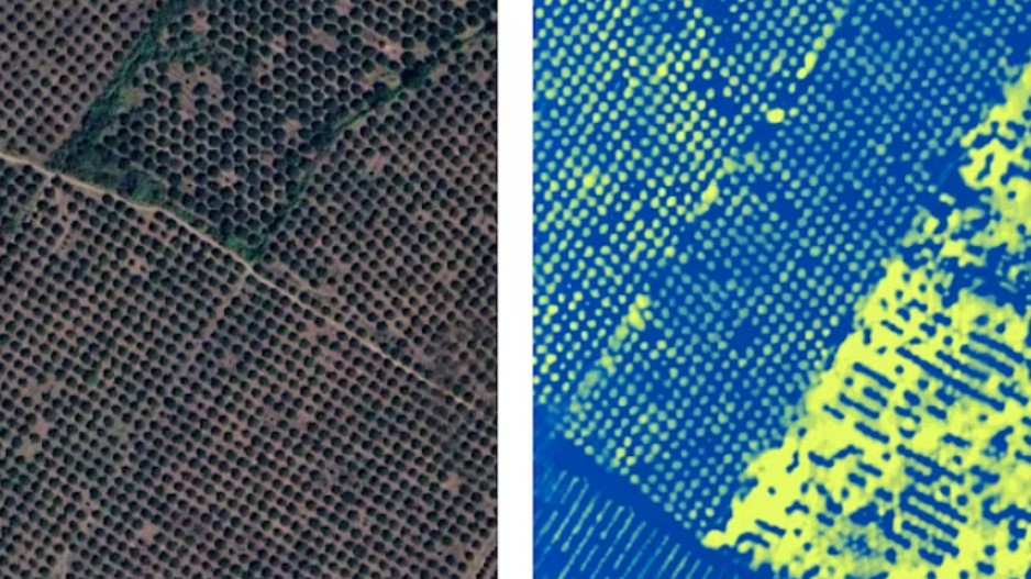
The model was applied in Troodos National Forest Park, where it successfully mapped nearly one million trees. It was also tested in Athalassa Forest Park and a small residential area in Aglantzia, covering a total area of 107 km².
Through this process, two detailed tree coverage maps were created for the Troodos Geopark and Athalassa Forest Park, with each tree canopy precisely recorded. Additionally, the data were used to estimate the total land area covered by trees across the Republic of Cyprus.
"This study lays the foundation for the first-ever comprehensive tree inventory and mapping system in Cyprus. By analyzing the results, we can assess key factors such as the impact of forest fires, the exact locations of burned areas, and the distribution of endemic tree species in Cyprus’ mountain regions," the researchers stated.
Furthermore, the study will provide valuable insights for forestry experts and government agencies to implement appropriate measures, such as reforestation and afforestation efforts in fire-affected areas.
For the first time in Cyprus, the study enables high-accuracy calculations of total forest biomass and the biomass of individual trees.
This advancement allows for the estimation of total carbon stocks absorbed by trees, significantly contributing to achieving the EU's carbon reduction targets aimed at combating the climate crisis.
The research was conducted under the Horizon Europe program Edu4Climate, funded by the European Union.